1 Overviewの最近のブログ記事
With more than 2000 hours of sunlight per year, Kagawa is representative of a warm Seto Inland Sea climate. Around 1000mm annual rainfall makes it one of the driest regions in Japan.
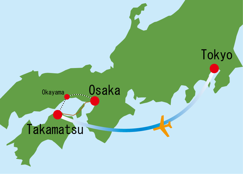
From Tokyo:
Haneda Airport to Takamatsu Airport: 60 minutes; Takamatsu Airport to downtown: 40 minutes
From Osaka:
Sanyou Line shinkansen to Okayama: 60 minutes; JR Seto-Ohashi Line to Takamatsu: 60 minutes
Kansai Airport to Takamatsu via JR: 3 hours; via bus: 3.5 hours

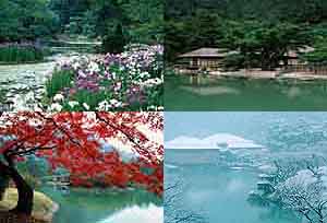
Prefectural Flowew and Tree: Olive
Prefectural Bird: Cuckoo
Prefectural Animal: Deer
Prefectural Fish: Yellowtail

Kagawa Prefecture is located in the north-eastern part of Shikoku, an island in the southwest of Japan. Playing a central role on the island, Kagawa is bordered on the south by the verdant Sanuki Mountain Range and to the north by the scenic Seto Inland Sea.

Kagawa Prefecture forms a half-moon; the Sanuki Mountains to the south reach heights of 800 meters and gradually descend north into the fertile Sanuki Plain. North of this is the Seto Inland Sea, home to more than 110 islands of various sizes.
With an area of 1876km2, Kagawa Prefecture is the smallest in Japan.

Kagawa is the 40th most populous prefecture in Japan, and its one-million people account for approximately 0.8% of the national population. It ranks 11th nationwide in terms of population density, however, with 540 people per square kilometer.

Kagawa is organized into 8 shi (cities) and 9 cho (towns). The largest city, Takamatsu, is home to the prefectural office and 420,000 people, 40% of the prefectural population.